


bdx002_0624

My Switzerland
Optez pour le retour à la nature GUIDE+
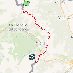

Length
14.8 km

Max alt
1986 m

Uphill gradient
1558 m
Km-Effort
36 km

Min alt
1382 m

Downhill gradient
1531 m
Boucle
No
Creation date :
2014-12-10 00:00:00.0
Updated on :
2014-12-10 00:00:00.0
8h15
Difficulty : Unknown

FREE GPS app for hiking
 SityTrail
IGN / Geographical institutes
SityTrail Plus
The world is yours!
About
Trail Other activity of 14.8 km to be discovered at Auvergne-Rhône-Alpes, Upper Savoy, La Chapelle-d'Abondance. This trail is proposed by My Switzerland.
Positioning
Country:
France
Region :
Auvergne-Rhône-Alpes
Department/Province :
Upper Savoy
Municipality :
La Chapelle-d'Abondance
Location:
Unknown
Start:(Dec)
Start:(UTM)
330504 ; 5132410 (32T) N.
Comments